Mostrar mensagens com a etiqueta cycling. Mostrar todas as mensagens

MegaSport Road Circuit 1 - Loule - Loule (via Malhao)

Één van de beste circuits van de Algarve.One of the best circuits that we have in the Algarve. Uitstekende weg, weinig verkeer, vele beklimmingen, een paradijs voor wielrenners.


Vergroting Kaart Malhão :

Dorpen en Stadjes die u passeert (met de klok mee):
-Loulé
-Alfeição
-Soalheira
-Alte
-Sarnadas
-Cortinhola
-Malhão
-Korte passage in de regio Alentejo
-Corte Pinheiro
-Vermelhos
-California
-Sarnadas
-Ameijoafra
-Andrezes
-Loulé
Afstand: 105km

Hoogte Grafiek:

Kaart overdragen naar GPS:


Foto's:

MegaSport Road Circuit 2 - Loulé - Loulé (Caldeirão kruisend)

Een zeer goed circuit, waar u in aanraking komt met de natuur en een prachtig landschap.De weg is goed, vele beklimmingen en weinig verkeer.

Kaart Caldeirão vergroten


Dorpjes die u langskomt (met de klok mee):
-Loulé (4 Estradas)
-Areeiro
-Alto do Relógio
-Goldra
-Gorjões
-Amendoeira
-Porto nobre
-Fonte Filipe
-Arrancada
-Querença
-Pirinéu
-Barranco do Velho
-Cortelha
-Miradouro do Caldeirão
-Cortiçadas
-Javali
-S. Brás de Alportel
-Vilarinhos
-Bordeira
-Sta. Bárbara de Nexe
-S. João da Venda
-Loulé (4 estradas)

Afstand: 108km

Hoogte Grafiek:


Kaart overdragen naar GPS:


Foto's:


MegaSport Road Circuit 3 -Vila Real de Santo António-Vila Real de Santo António ( Via Alcoutim)

An accessible route for all ages, with fantastic views and also with a passage in the Odeleite and Beliche Dams.

See Mapa Estrada Vila Real - Alcoutim in a bigger map 


Passages on the way (Counter Clockwise):
-Vila Real de Santo António
-Junqueira
-Azinhal
-Almada D'Ouro
-Fonte do Penedo
-Alcaria
-Foz de Odeleite
-Álamo
-Guerreiros do Rio
-Laranjeiras
-Quatro Estradas (Alcoutim)
-Balurcos de Baixo
-Odeleite
-Portela Alta
-Beliche
-Botelhas
-Vila Real de Santo António

Distance: 97km

Height Graphic:


Transfer File to GPS:
Track

Images:


Megasport Road Circuit Nº4: Monte Gordo - Monte Gordo (Through Vaqueiros)

Mapa com bastantes subidas e paisagens fantásticas, onde se consegue ver o serpentear da estrada nas serras Algarvias por vários quilometros.


Ver Monte Gordo - Monte Gordo (Via Vaqueiros) num mapa maior


Passages on the Way (Clockwise):
-Monte Gordo
-Altura
-Manta Rota
-Cacela Velha
-Ribeira do Junco
-Santa Rita
-Ribeira da Gafa
-Champana
-Corte António Martins
-Cortelha
-Alta Mora
-Pernadeira
-Casas Novas
-Cabaços
-Vaqueiros
-Malfrade
-Monte das Perguiças
-Varzea
-Fernão Gil
-Alfarrobeira
-Eira Verde
-Corte Pequena
-Corujos
-Barreiros
-Corte do Gago
-Rio Seco
-São Bartolomeu
-Monte Gordo

Distance: 113 km

Height Graphic:

Transfer File to GPS:

Images:

MegaSport Road Circuit 5 - Portimão - Portimão (through Fóia-Monchique)

High quality circuit for road cycling, with a climb to the highest spot in the Algarve (Fóia, with 900mt Height), with fantastic landscapes along the path. Enjoy here a circuit that crosses the heart of Serra de Monchique, one of the most pleasant and beautiful places in the Algarve, crossing high quality roads with few traffic, ideal for those who like a real cycling challenge.


Ver mapa maior


Locations and points of interest along the path (Clockwise):
-Portimão
-Penina
-Monumentos Megalíticos

-Autódromo
-Pereira
-Gordeiro
-Corte Cibrão
-Enxameador
-Zanganilha
-Marmelete
-Passil
-Besteiro
-Cabeço
-Selão
-Cova da Serva
-Portela da Viúva
-Monchique
-Malhada Quente
-Umbria
-Alferce
-Pedra Branca
-Pardieiro
-Cortes
-Laranjeira
-Monchicão
-Quinta do Francês
-Porto de Lagos
-Ladeira do Vau
-Macheiro
-Portimão

Distance:118 km

Height Graphic:

Transfer File to GPS:


Images


MegaSport Road Circuit 6 - Albufeira-Albufeira (Via Paderne)

Road Circuit with easy dificulty level, ideal for cyclers with little experience, few climbs and good roads. Circuit in urban region.


See Albufeira Ciclismo in a bigger map


Locations Along the Path (Clockwise):
-Albufeira
-Guia-Algarve Shopping
-Tunes
-Purgatório
-Alcaria
-Lentiscais
-Paderne
-Fonte de Paderne
-Tenola
-Recanto
-Boliqueime
-Albufeira

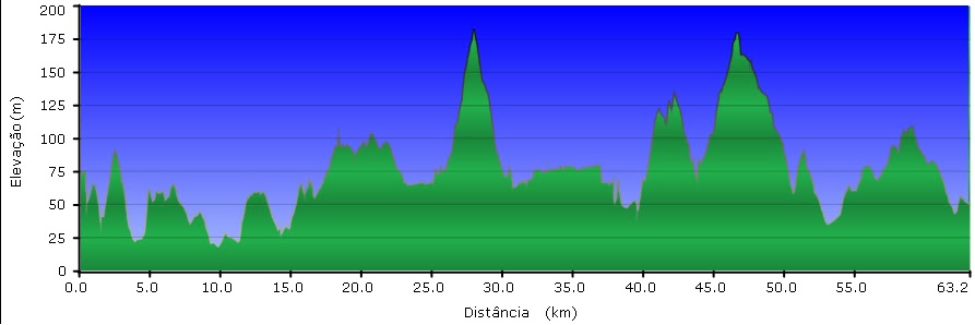
Distance: 63 km

Height Graphic:

Transfer File to GPS:

Images:


MegaSport Road Circuit 7 - Tavira-Tavira (Via Faz Fato)

Small circuit that allows the initiates to be in touch with this modality and with the climbings that can be found, and also provides the possibility to see the beautiful landscapes of this region. Few traffic.


See Tavira mapa 1 in a bigger map


Locations and  Points of Interest  along the path (Counter Clockwise):
-Tavira
-Camping Park of Tavira and hospital
-Pedras da Rainha
-Cabanas de Tavira
-Nossa Senhora da Vila Main Church
-Cumeada
-Solteiras
-Eiras
-Eirões
-Vale Rosado
-Monte da Estrada
-Estorninhos
-Faz Fato
-Castelos
-Almargem
-Tavira

Distance: 45km

Height Graphic:


Transfer File to GPS:

Images:


MegaSport Road Circuit 8 - Tavira-Tavira (Via Cachopo)

Long circuit in the region of Tavira. Great for this modality sportsmen, with fantastic landscapes, some climbings and good paving.


See Tavira mapa 2 in a bigger map

Locations Along the Path ( Counter Clockwise)
-Tavira
-Vale do Junco
-Vale da Murta
-Portela dos Vales
-Portela da Corcha  (Zone with Snack bar)
-Água dos Fusos
-Alcaria do Cume
-Monte da Ribeira
-Cachopo
-Almarguinho
-Catraia
-Feiteira
-Montes Novos
-Bicas da Serra
-Alportel
-S. Brás de Alportel
-Sta. Catarina da Fonte do Bispo
-Fonte do Bispo
-Prego
-Cruz do Areal
-Sta. Margarida

Distance: 100km

Height Graphic:

Transfer File to GPS:

Images:


MegaSport Road Circuit 9 - Tavira-Tavira (Via Luz de Tavira)

Small circuit, ideal for cyclists with little experience and to initiate children and youngsters in road cycling. Few climbings, intense contact with Nature in very beautiful places and also cultural with the passage in several localities.


See Tavira Mapa 3 in a bigger map


Places along the Path (Counter Clockwise):
-Tavira
-Moinhos da Rocha (600 meters of Pego do Inferno)
-Monte Agudo
-Santo Estevão
-Sinagoga
-Luz de Tavira
-Amaro Gonçalves
-Fundo
-Pedras d'el Rei
-Sta. Luzia
-Tavira

Distance: 37km

Height Graphic:

Transfer File to GPS:

Images: